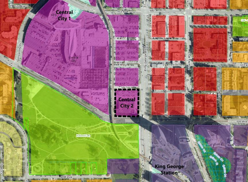
Public consultation is set to get underway this month for the proposed Surrey Langley SkyTrain (SLS) extension, as well as the future of rapid transit along 104 Avenue & King George Blvd.
In 2014, the regional Mayors Council identified Fraser Highway, King George Boulevard, and 104 Avenue as priority corridors for rapid transit South of the Fraser in the 10-Year Vision. Following a study looking at combinations of SkyTrain, LRT, and Bus Rapid Transit for the corridors, the Mayors Council decided on 27-km of urban-style LRT on dedicated track (separate from traffic) on each of the corridors to be built over 2 phases:
- Phase 1: Surrey-Newton-Guildford Line on 104 Avenue & King George Boulevard
- Phase 2: Surrey-Langley Line on Fraser Highway
With funding in place to cover the entire first phase, and construction set to begin this year – a last minute request was made in 2018 by Surrey’s new Council to the regional Mayors’ Council to suspend the Phase 1 Surrey-Newton-Guildford LRT line and re-direct funding to the Phase 2 Surrey-Langley line instead, while switching the technology of the Phase 2 line to SkyTrain. The Mayors’ Council voted to move forward with this request, and directed TransLink to begin planning work for SkyTrain on Fraser Highway while at the same time re-visit rapid transit plans for 104 Avenue and King George Boulevard corridors.
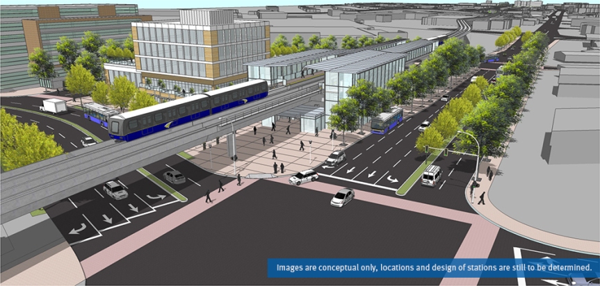
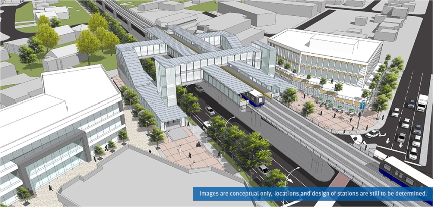
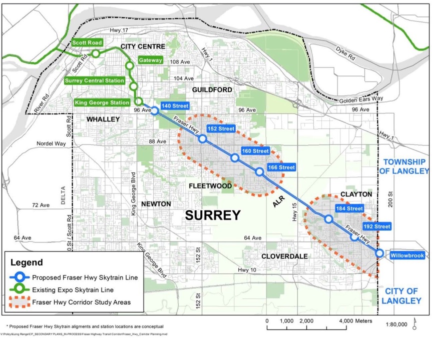 Proposed Surrey Langley SkyTrain route and conceptual stations
The switch of priorities to the Phase 2 Fraser Highway line and changing its technology to SkyTrain has had implications both in budget and timeline. The funding that was allocated for the full Phase 1 Surrey-Newton-Guildford LRT line has been identified as inadequate to fund the entire Fraser Highway SkyTrain extension to Langley. Pending a future round of funding (timeline unclear), the line may have to be phased, with the current funding getting the line potentially only as far as Fleetwood. Start of construction and delivery of new rapid transit South of the Fraser is also now delayed by approximately 2 years as a result of the switch.
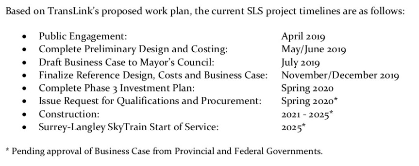
Despite the funding and timeline uncertainties, planning work is nonetheless well underway for the new SLS line, which will need to involve a significant re-evaluation of land-use plans along the Fraser Highway corridor to support SkyTrain, completion of a number of supportive studies, and extensive Public Consultation. In a project update report to Surrey Council this week – a preliminary timeline was given for this work by TransLink, with start of service targeted for 2025.
To run concurrently with the SLS planning and consultation work will be a planning process to ‘refresh’ the South Fraser Rapid Transit Strategy for delivering the Mayors’ Council fully envisioned 27km of Rapid Transit along each of the Fraser Hwy, King George Blvd, and 104 Ave corridors. This refresh will look to re-examine and engage the public on what rapid transit along the remaining corridors could look like, now that SkyTrain has been chosen as the technology for Fraser Hwy. The 2013 Rapid Transit Alternatives Study identified Bus Rapid Transit (BRT) for these corridors based on a scenario with SkyTrain on Fraser Hwy. With much LRT planning work having now been completed however, for the 104 Ave and King George Blvd corridors, it’s possible that LRT could still be an option for them rather than BRT, especially given Surrey’s long-term rapid transit vision for an extensive LRT network on major arterials across the City.
The first round of Public Consultation on the SLS line and South Fraser Rapid Transit refresh gets underway on April 11 in Langley, with open houses in Surrey on April 15, 16, and 17. TransLink has also recently launched an online survey where you can voice your feedback on the proposed SLS line. Open House times are set for the following dates and locations between 3-8pm:
- Thursday, April 11 – Langley City Hall
- Monday, April 15 – Surrey Sport & Leisure Complex (Fleetwood)
- Tuesday, April 16 – Surrey City Hall
- Wednesday, April 17 – Newton Seniors Centre
More info on the land-use planning review process for the Fraser Highway Corridor being undertaken by the City of Surrey can be found here: https://www.surrey.ca/bylawsandcouncillibrary/CR_2019-R059.pdf

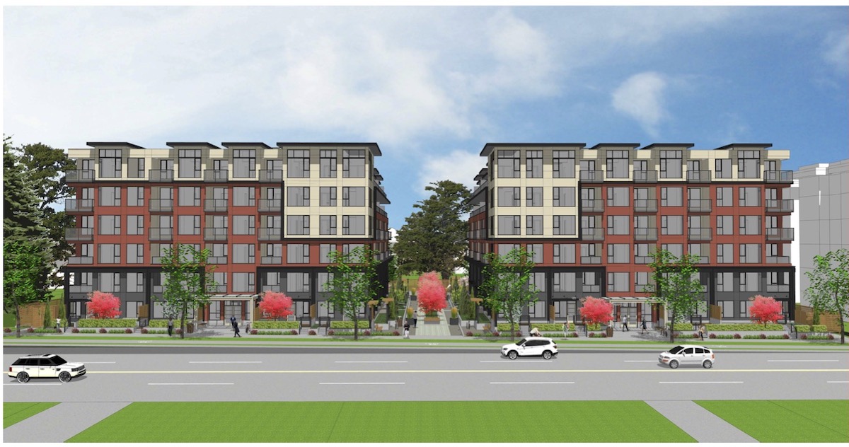
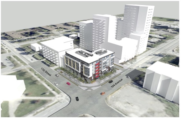
A development application has been submitted for a new mixed-use project on 104 Ave near Whalley Blvd. The subject site is made up of 3 existing properties that span the block between 104 Ave and Central Ave just east of Whalley Blvd. The site is currently occupied by a run-down early 1970’s strip mall known as ‘Plaza 104’.
According to details of the development application, the applicant – Andrew Cheung Architects – is seeking to rezone the property and amend both the Official Community Plan and City Centre Plan for increased density from 3.5 FAR to 5.5 FAR to allow for a phased 1149 unit mixed-use development containing 10,720 sq.ft. of commercial space. This translates into approximately 3 high-rise residential towers above retail. In addition, the development would dedicate a new north-south road through the site, as well as 2 new lanes as per the City Centre Plan.
The current application is seeking a Development Permit for phase 1, which is to contain a single tower (383 units) and all 10,720 sq.ft. of commercial space on a newly subdivided parcel fronting 104 Avenue. The remaining phases of the project to the south would be subject to future applications.
 Site in context of the City Centre Plan showing future road and lane dedications
  Subject Site on 104 Avenue east of Whalley Blvd containing a 1970’s strip mall
  Birds-eye view of site looking south from 104 Ave
For more on the application: https://apps.surrey.ca/Online-Development-Inquiry/?year=19&seq=0060
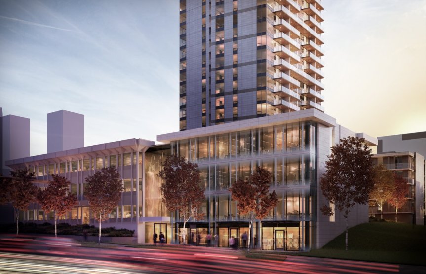
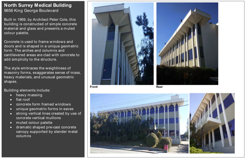
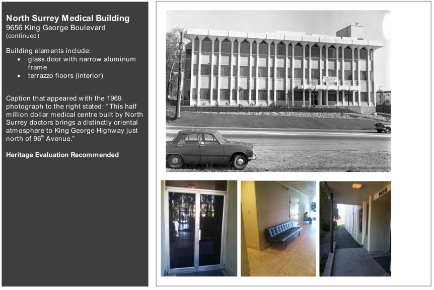
A heritage revitalization project being proposed by Vancouver developer Rize Alliance at 9656 King George Blvd just north of Surrey Memorial Hospital, received unanimous approval by Surrey’s Advisory Design Panel (ADP) on February 14. The project, which must still appear before Council for approvals, is proposing to restore the 1969-built North Surrey Medical Building, while adding a new ‘twin’ commercial podium, and residential tower to the site.
The North Surrey Medical Building is listed in the Surrey City Centre Plan as a ‘Potential Heritage Resource’. If approved, the project will officially add the building to the City’s Heritage Register, and help to preserve and enhance mid-century heritage within the City Centre – a goal of the City Centre Plan.
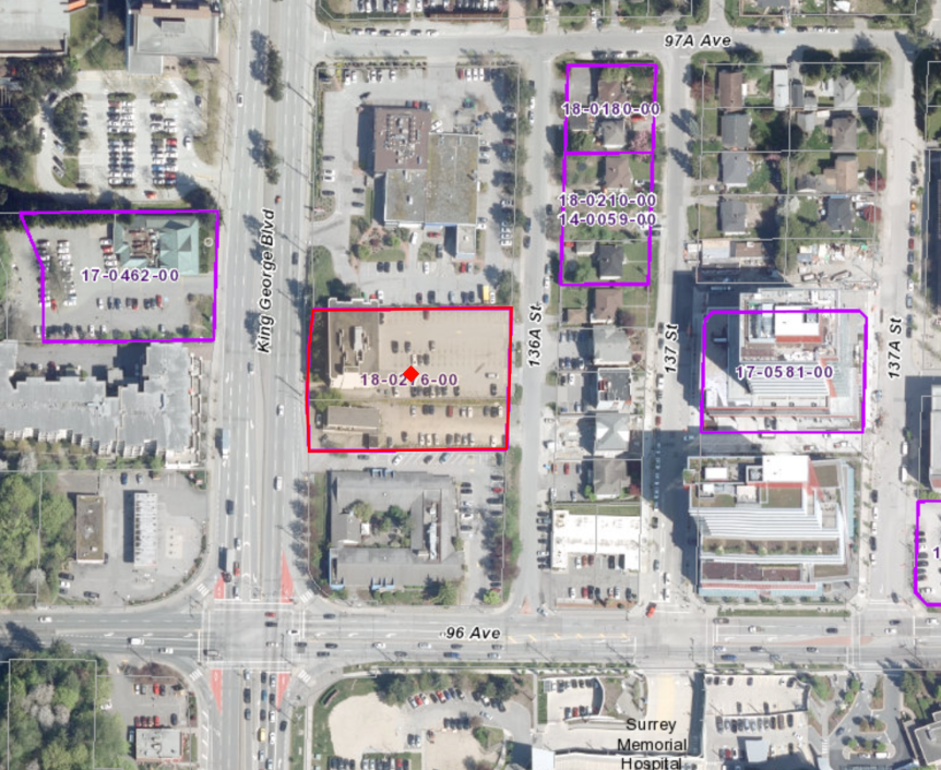 Subject Site at 9656 King George Blvd
Aside from the Heritage Revitalization Agreement for the North Surrey Medical Building, the proposal is seeking to Rezone the subject site from CHI to CD, Consolidate 2 lots into 1, and obtain a Development Permit in order to construct 276 residential units and 1486 sq. m. of commercial space. The new commercial space is to occupy a new ‘twin’ 4-storey podium consisting of ground floor retail and 3 floors of office – adjacent to and resembling the original 1960’s building.
Now that the project has passed ADP – it can be expected to appear before Council within the coming months. More renderings and project details can also be expected at that time.
For more on the proposal: https://apps.surrey.ca/Online-Development-Inquiry/?year=18&seq=0276
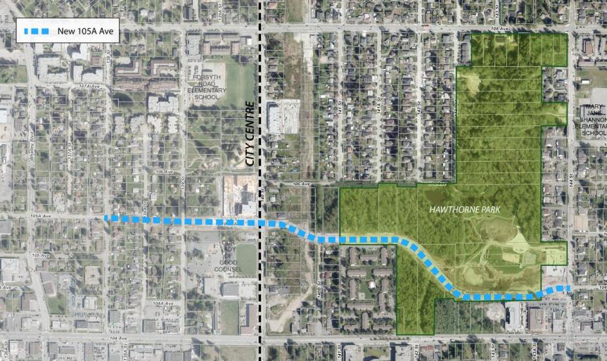
Early last year, work began on the 105 Avenue Connector and Hawthorne Park Improvements project. The purpose of the project was to improve connectivity between City Centre and Guildford through a new multi-modal collector road, as well as deliver numerous improvements to Hawthorne Park – including improved accessibility, a new aquatic habitat, and increasing the park’s overall size.
Since then, Phase 1 of the project, including the 105A Connector between Whalley Blvd and 144 Street has mostly completed, with some finishing touches remaining between 139 Street and 140 Street. The new 105A Avenue is a multi-modal corridor featuring 2 vehicle lanes, grade separated bike lanes, sidewalks, boulevards, fencing, and enhanced pedestrian-oriented street lighting. The route offers pedestrians and cyclists a pleasant alternative to 104 Avenue, skirting the edge of Hawthorne Park and continuing west past 140th Street into City Centre.
Below is a small photo tour of the new 105A and park improvements.
 Completed phase 1 of 105A Connector project
 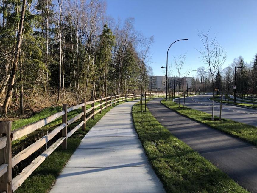 New 105A Ave though Hawthorne Park with sidewalk, bike-lane, and roadway
 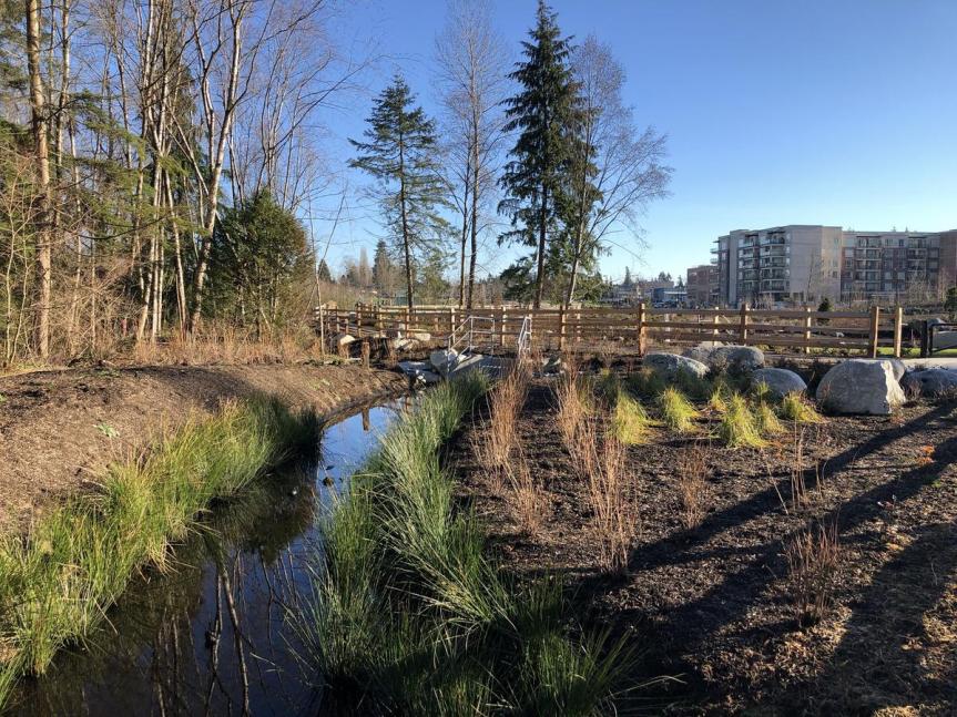 New landscaping and habitat area
 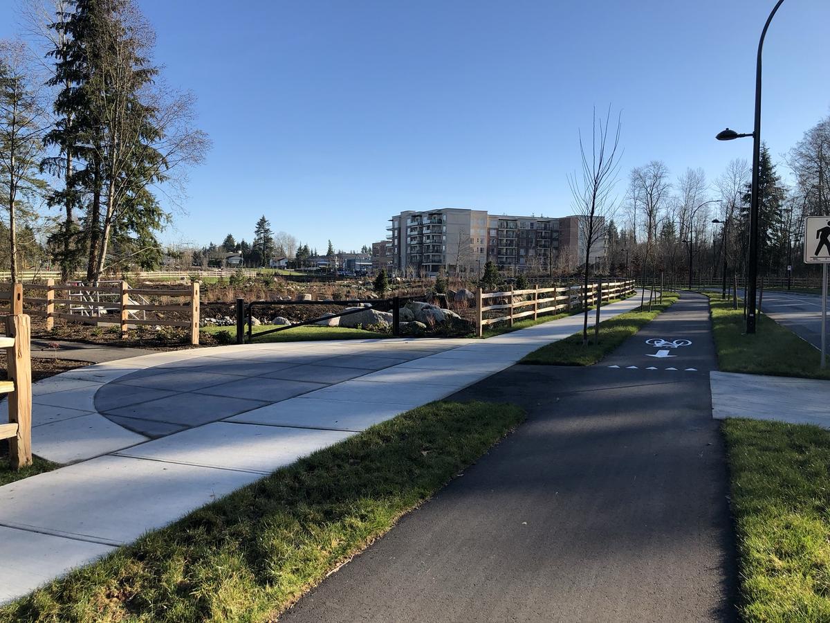 New sidewalk and bike lane near Aquatic Habitat
 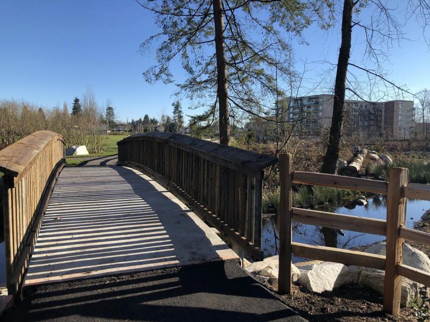 New pedestrian bridge over aquatic habitat
 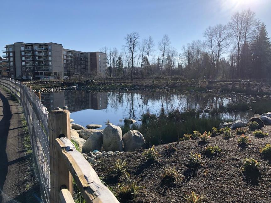 New Aquatic Habitat at Hawthorne Park
 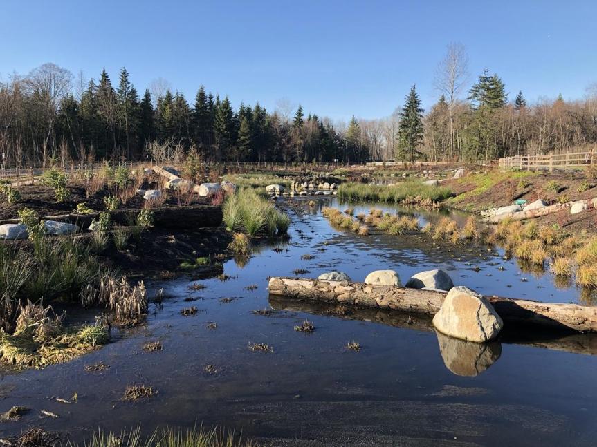 New Aquatic Habitat in Hawthorne Park
 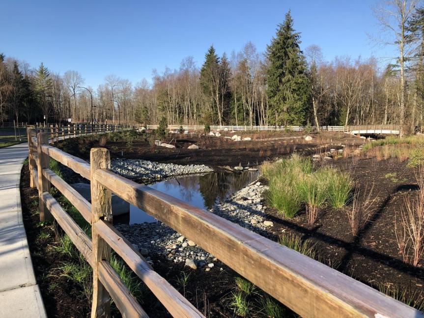 New Aquatic Habitat from 105A Ave
 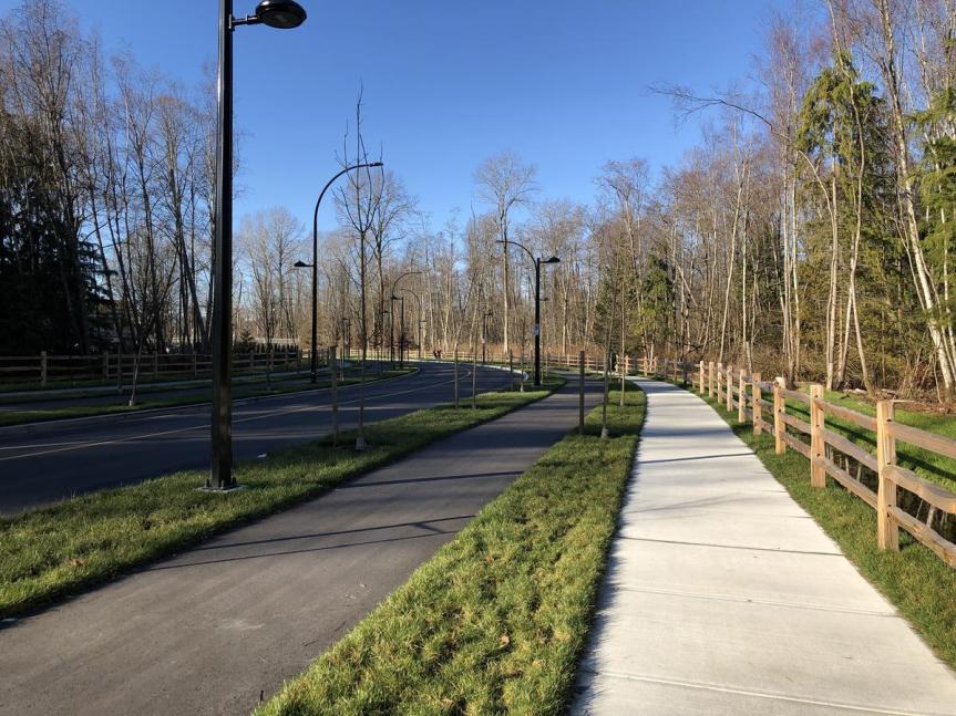 New 105A Avenue along south edge of Hawthorne Park
  New 105A Avenue between 139 Street and 140 Street
  New 105A Avenue between 139 Street and 140 Street
More info on the 105A Connector and Hawthorne Park Improvements Project can be found on the City’s website: https://www.surrey.ca/city-services/22562.aspx
Or take a visit for yourself!
With Doug McCallum’s win in last weekend’s election, Surrey appears to be in for change. Campaigning heavily on LRT and Safety, the topic of discussion now is whether he will deliver on his promise to ‘scrap’ LRT and ‘replace’ it with SkyTrain. It appears the majority of Surrey residents are in favour of this – fuelled by non-stop negative publicity of LRT in the media – but what does an LRT to SkyTrain ‘switch’ actually mean for Surrey? A few key implications to consider:
SkyTrain vs LRT – 2 different routes
A misconception that many who ‘voted’ for SkyTrain over LRT may have may have is that the proposed LRT will simply be ‘switched’ to SkyTrain. This is not the case – each would run along a different route. Let’s look at the difference:
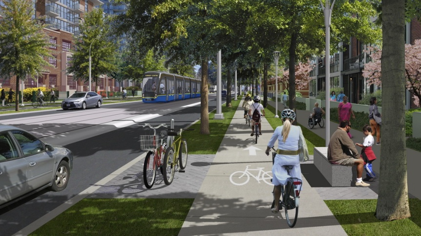
LRT – City Centre-Newton-Guildford: The proposed ‘Phase 1’ LRT route – with secured funding and significant planning and design work already completed – is planned run from Guildford along 104 Avenue to City Centre, then south on King George Blvd to Newton. This is known as the ‘L’ Line or Surrey-Netwon-Guildford Line – serving Surrey’s most populated, and urban town centres.
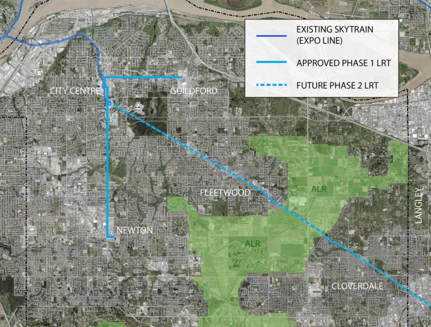 Phase 1 LRT route along 104 Ave & King George Blvd + future Phase 2 route to Langley
SkyTrain – Fraser Highway: Doug McCallum’s SkyTrain – which would need to be planned and designed from scratch – would provide no rapid transit to Guildford or Newton (Surrey’s most populated / urban town centres) – but instead be an extension of the existing Expo Line down Fraser Highway to Fleetwood, Cloverdale (Surrey’s least populated / urban town centres) and Langley.
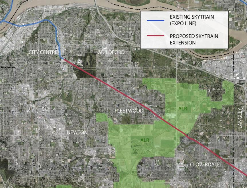 SkyTrain extension to Langley along Fraser Hwy through low density suburbs / ALR to Langley
The Land-Use Difference
LRT: The proposed ‘Phase 1’ LRT route would serve Surrey’s most established urban corridors with the highest densities – 104 Avenue and King George Blvd. Guildford Town Centre contains the regions 2nd largest shopping centre, numerous high-rises and offices. Further, the currently underway Guildford-104 Avenue Corridor Plan which is set to become adopted in 2019, has designated land all along 104 Avenue between City Centre and Guildford for increased urban densities appropriate for a rapid transit corridor. A similar plan is set to follow for the King George corridor between City Centre and Newton. Simply put – 104 Avenue and King George Blvd are the most appropriate corridors for initial rapid transit expansion in Surrey due to their already underway land-use planning for higher density, and their existing densities, land-use, and most urban character of Surrey’s corridors.
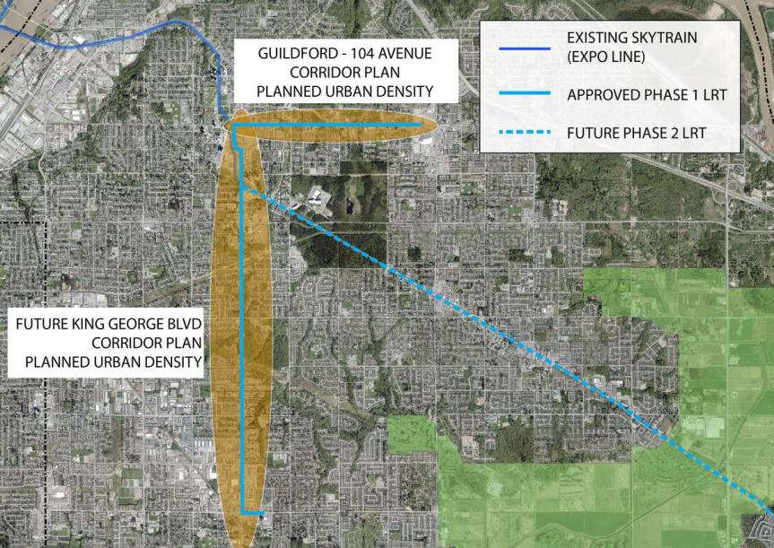 Phase 1 LRT route along existing urban corridors with planned density
  Guildford – 104 Avenue Corridor Plan – urban density planned along LRT route
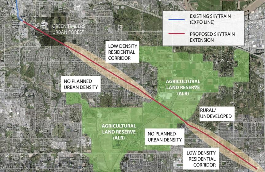
SkyTrain: Doug McCallum’s SkyTrain would run down Fraser Highway which currently has no land-use plans for significant urban density underway, and is currently of the lowest density and suburban of corridors in Surrey. The SkyTrain route would run through:
- Green Timbers Forest for the first 2km of its route
- the low density suburban neighbourhood of Fleetwood for the next 5km
- ALR farm land for the next 2km
- and finally low density suburban Clayton/Cloverdale and Langley for the remaining 6km of the route
This route would have the lowest densities of any SkyTrain corridor in the region – including significant stretches through forest and ALR farm land – unseen anywhere else on the SkyTrain system. SkyTrain along Fraser Highway would require significant land-use changes along Fraser Highway to justify it – including significant increases in density, high-rise towers, and transit-oriented development – similar to elsewhere along the SkyTrain network. This would require changes to the Official Community Plan (OCP) – ironically Doug McCallum campaigned against OCP amendments.
Simply put – this type of development is incompatible with the scale and character of the Fraser Highway corridor that is predominantly newer single family homes and townhomes. Many living along that corridor would surely object to such drastic land-use changes appropriate for a SkyTrain line.
 SkyTrain extension through low density suburbs / ALR with no planned urban density
From a land-use planning perspective – it makes the most sense to serve the highest density corridors and urban centres (104 Avenue – King George Blvd) with rapid transit prior to lower density corridors such as Fraser Highway. Instead, a SkyTrain extension over LRT would do the exact opposite of what makes sense. While it is important to provide a rapid transit link to Langley, and connect the communities of Fleetwood, Clayton/Cloverdale with regional rapid transit – from a land-use and planning perspective these areas are lower priority than Guildford and Newton – and Fraser Highway does not have density appropriate for SkyTrain. In an ideal world, Langley would be serviced by long-distance commuter rail such as all-day WestCoast Express – but realistically – LRT may be the best option for serving Langley down Fraser Highway as a Phase 2 project – given the density, scale, and character of that corridor.
Uncertain Timeline
LRT: Funding for the proposed ‘Phase 1’ LRT route is “in the mail” from the Federal and Provincial Governments. Significant planning, consultation work, and design has been underway for years, and the project is now at the procurement stage with construction set to begin in 2019 and completion by 2024.
 LRT scheduled to begin construction in 2019 – years of planning, consultation, design already complete.
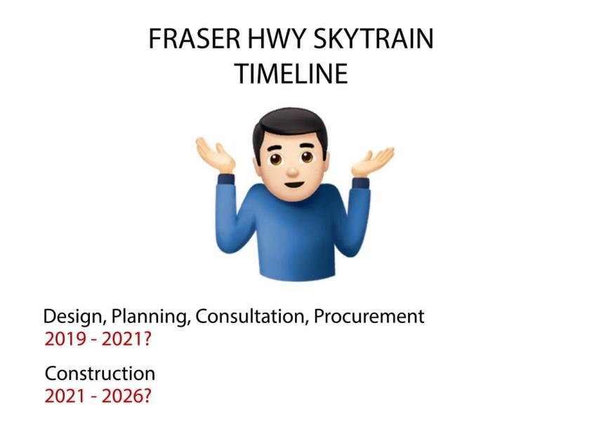
SkyTrain: Doug McCallum claims that secured funding for LRT can simply be ‘switched’ to fund a SkyTrain extension to Langley instead of the Guildford Newton line. While this may be possible, as the funding doesn’t specify a type of rail – the fact is – no planning, consultation, or design work has been completed on a SkyTrain extension down Fraser Highway. The amount of time and additional resources that would need to go into a SkyTrain extension prior to its construction would not only delay the project for an unforeseen number of extra years – pushing completion of this line to the late 2020’s.
By that time, Phase 2 of the LRT is likely to be under construction – resulting in Surrey having 2 new rapid transit lines by the late 2020’s instead of just a single SkyTrain extension down low-density Fraser Hwy within the same time frame.
While these reasons aren’t exhaustive in the debate – they are very key ones that have been surprisingly absent talking points. Surrey residents may not have been the best informed on the SkyTrain vs LRT debate thanks to the media – to make an educated decision that weighs more factors than just ‘speed of service’ and ‘glamour of SkyTrain vs LRT’ – but in the end it may not matter. The LRT project is likely too far along at this stage and with too much else to consider to simply be ‘switched’. It is being led by non-partisan land-use and transit planning experts in the Planning & Transportation Departments (not the former Mayor or Councillors as some may believe) – experts who should be leading such projects – rather than transit planning on a whim by politicians and voters.

Blackwood Partners, have released new details on their upcoming ‘Central City 2’ office tower project at the corner of Old Yale Rd and King George Blvd. A new leasing brochure, available on the Central City website, provides some updated renderings, floorplans, and marketing information aimed at future tenants looking for office and retail space.
Since first being announced back in November 2017, the new renderings depict a re-designed, more refined tower, from that initially conceptualized. The new design features a stronger podium fronting Old Yale Rd and a more cohesive tower floor-plate and massing compared to the previous design. The rectangular floor plate blends into an elliptical floor plate on higher floors – referencing the existing 25-storey Central City office tower at 102 Ave & University Dr built in 2003.
 Conceptual rendering of tower podium and restaurant at corner of City Parkway and Old Yale Rd
Tower Details
Designed by Vancouver’s ZGF Architects, the project will be a 25-storey, Class AAA, mixed- use tower, containing 512,305 SF of commercial space and +/-20,000 SF of retail space contained within the podium. The ground level is conceptualized to contain 6 retail units, a restaurant, cafe, and office tower lobby, anchored to a prominent public plaza at the corner of Old Yale Rd and King George Blvd across from Holland Park and King George Station. The building will be built to LEED GoldDesign (with a pathway to Platinum), and also contain:
- Premium end-of-trip facilities, with ample bicycle storage, executive bicycle lockers, shower, and change facilities
- Approximately 900 underground parking stalls
- High-speed state-of-the-art elevators
- Electric vehicle charging stations and car share parking spaces.
- Numerous other advanced technology features
 Conceptualized ground-level floor plan
  Artistic rendering of views from higher-level office floors
  Artistic rendering of roof-top views overlooking Holland Park
  Artistic rendering of fitness facilities for office employees
Long-term plan
Also released as part of the leasing brochure is a glimpse at the long-range plan for redevelopment of the entire Central City site following Central City 2. This plan will see much of the existing indoor shopping centre retained but renovated, with the introduction of a new prominent plaza at its south-end along Old Yale Rd, linking the shopping centre directly onto Holland Park. The existing parking lot along King George Blvd is envisioned to be broken up into a series of new city blocks, containing mixed-use high-rise development sites. A re-aligned City Parkway will connect directly through the site from the north, past a new entry plaza where Wal-Mart currently exists.

While no target dates have been given for completion of Central City 2 – it is expected that a development application will be submitted for the project in the near future. The long-range plan for Central City is expected to play out over the next decade or longer. For more on Central City 2:
http://www.centralcity.ca/wp-content/uploads/2018/04/Tower-2-at-Central-City-Brochure-April-2018.pdf

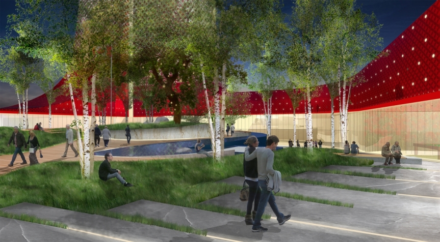
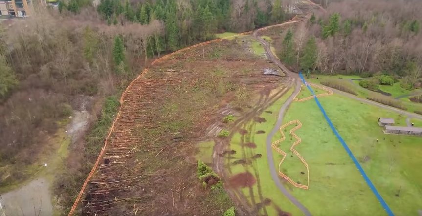 Captured image from drone footage showing clearing along southern edge of Hawthorne Park.
 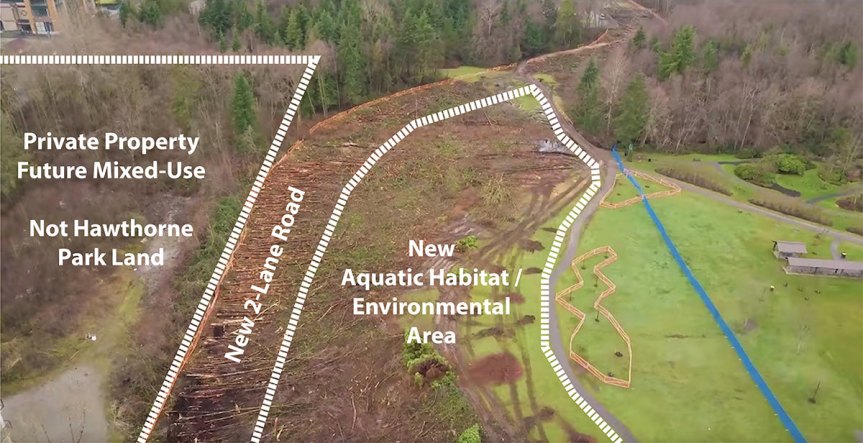 Cleared area in perspective – majority to be used for new aquatic habitat/environmental area. Lands to south are private property outside park designated for future mixed-use.
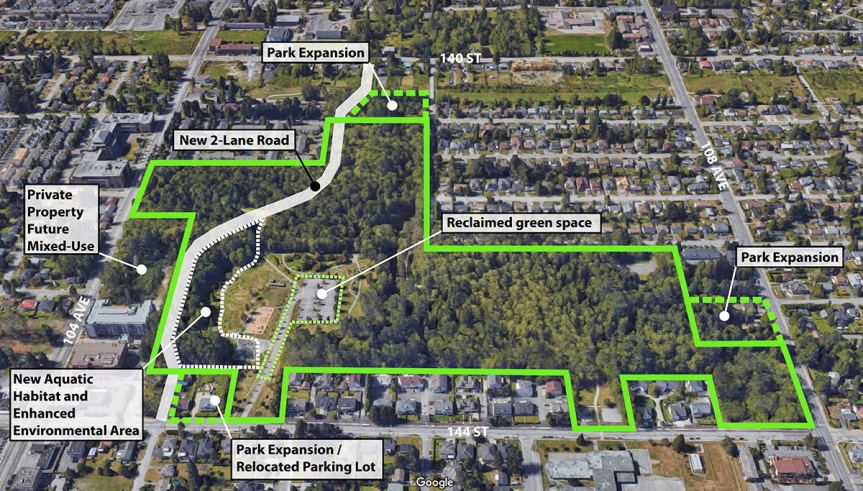 105A connector routing through the southern edge of Hawthorne Park in perspective. Vast majority of park to be preserved, expanded, and enhanced.
 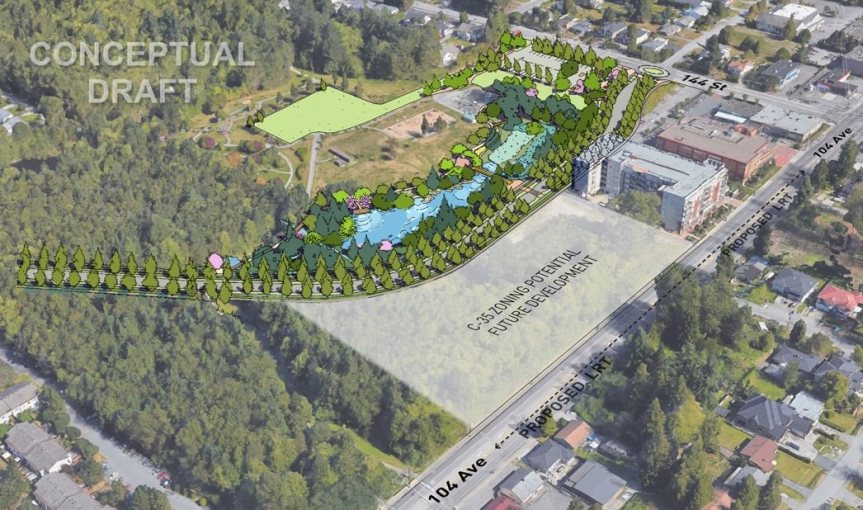 Artist rendering of new 2-lane 105A connector and new aquatic habitat, environmental enhancement area, and future development site south of 105A Avenue outside of Park.
 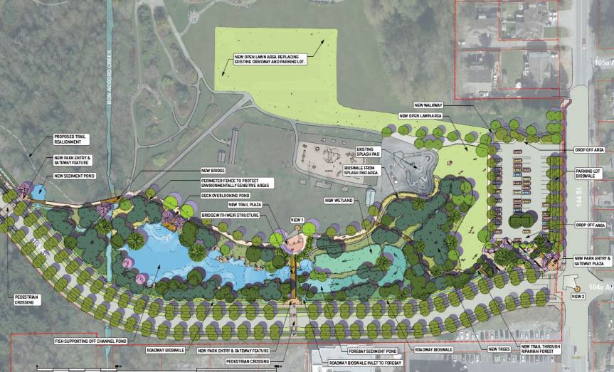 Artist rendering of new 2-lane 105A connector along edge of Hawthorne Park and new aquatic habitat, environmental enhancement area, and relocated parking lot/reclaimed green space.
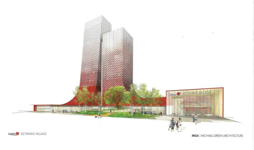
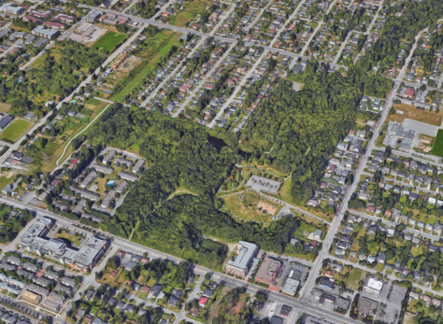 Google Earth view of Hawthorn Park looking north from 104 Ave
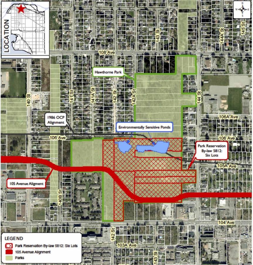 Properties affected by the 1979 Bylaw preserving lands for parkland
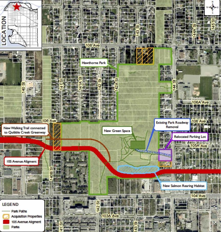 Proposed alignment of 105 St and Park Improvements
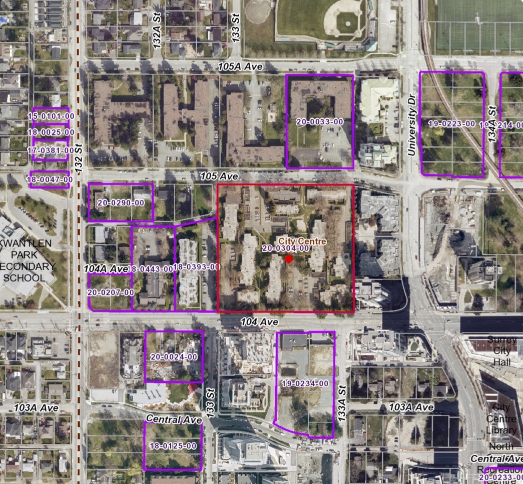
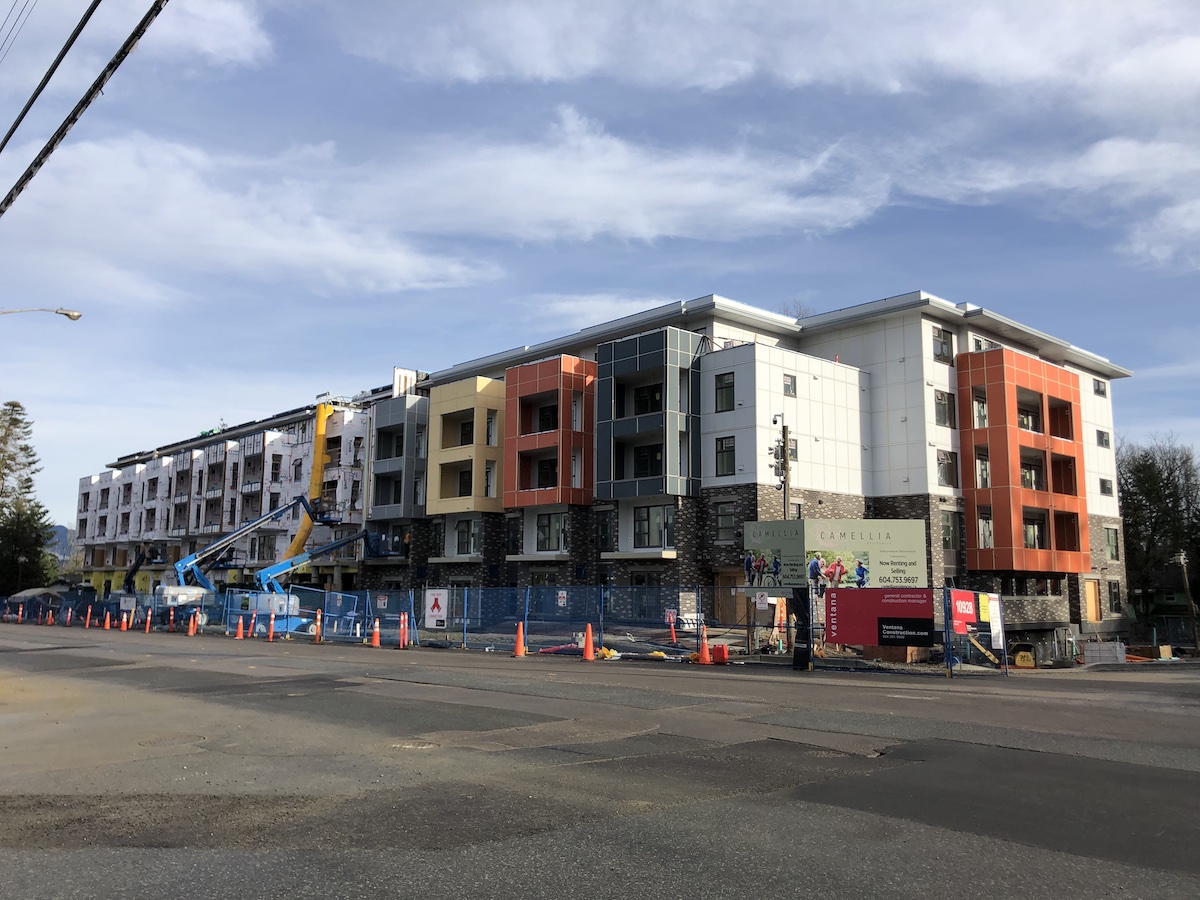 Camellia | 5-Storey Seniors Residential | 132 St & 109 Ave
  One Central | 44-Storey Residential + Retail | 133 St & Central Ave
 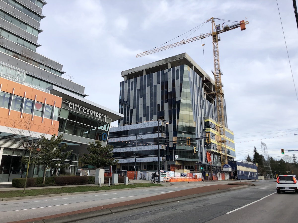 City Centre 3 | 10-Storey Office + Retail | 96 Ave & 137A St
  University District | 28 & 37-Storey Residential + Retail | University Dr & 104 Ave
  Linea | 28-Storey Residential | 133A St & 104 Ave
  Legion Veterans Village | 20-Storey Mixed-Use | City Parkway & 106 Ave
 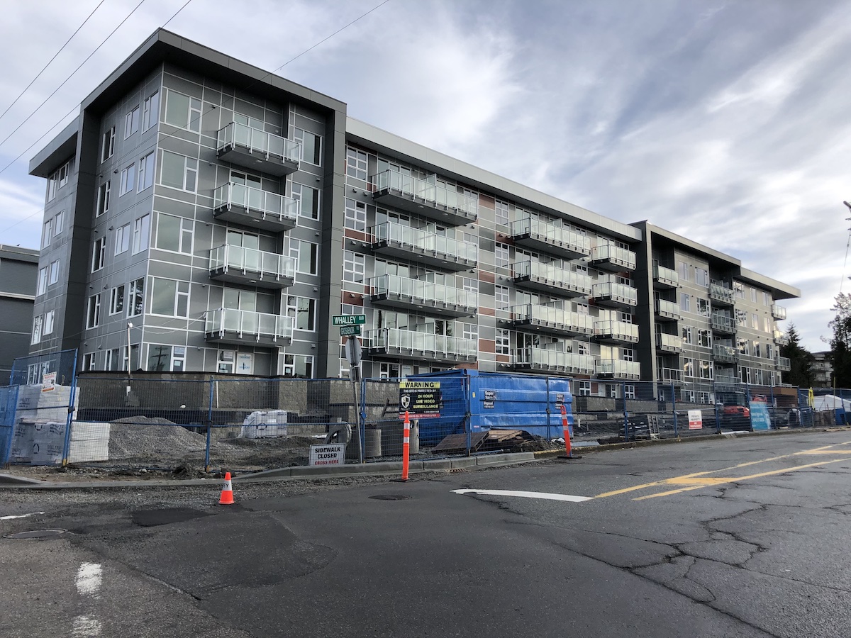 Maverick | 5-Storey Residential | Whalley Blvd & Grosvenor Rd
  King George Hub (Phase B + C) | 29, 34 & 40-Storey Residential + 15-Storey Office + Retail | King George Blvd & Fraser Hwy
  King George Hub (Phase B) Retail Component | King George Blvd & Fraser Hwy
 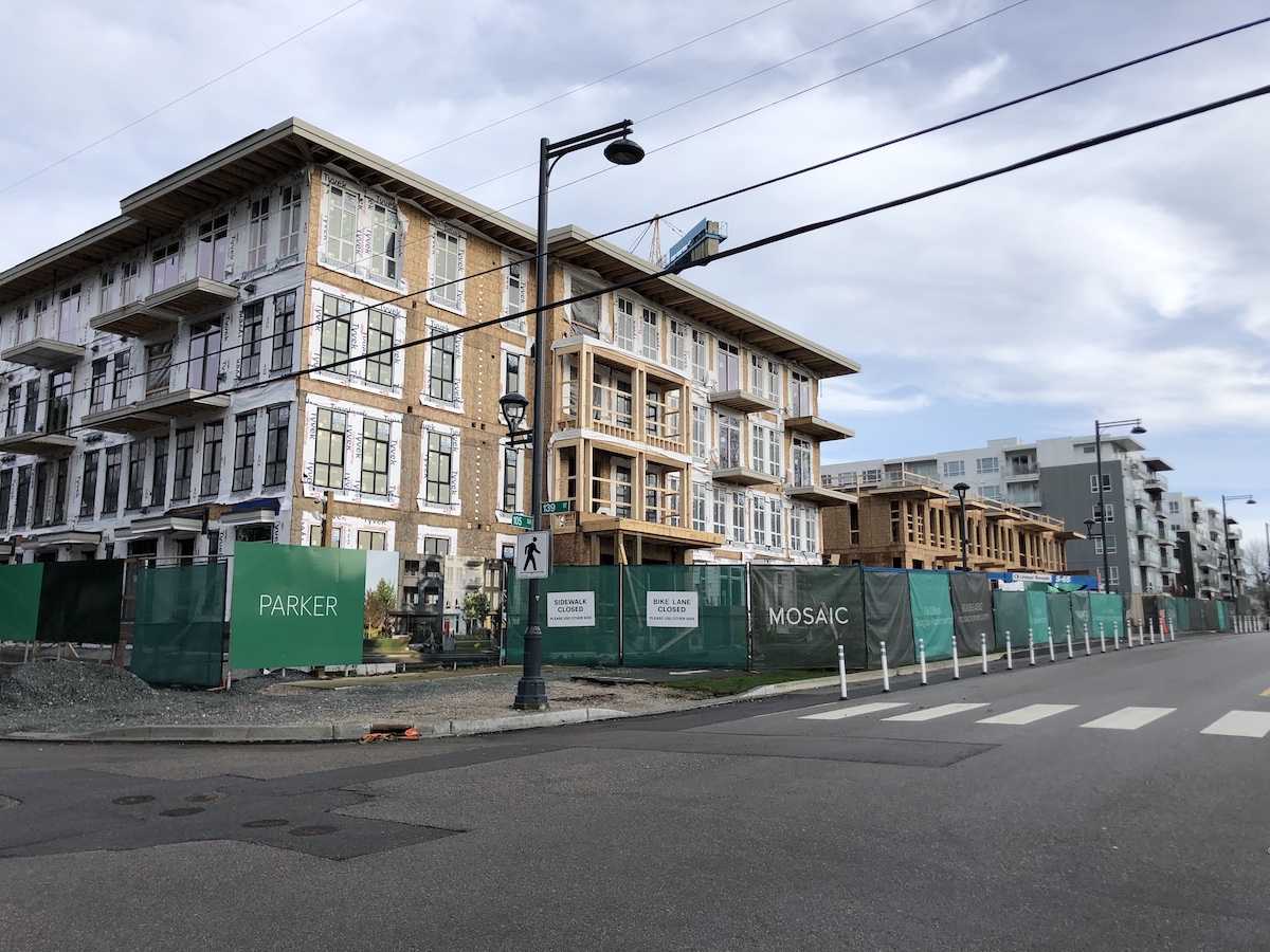 Parker | 4-Storey Residential | 139 St & 105 Ave
 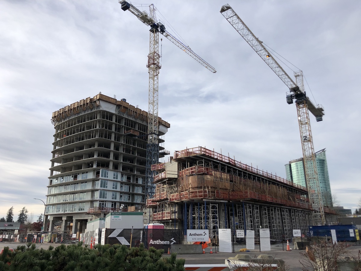 Georgetown One | 30-Storey Residential + Retail | 102 Ave & Whalley Blvd
 Perspective along King George Blvd – Rental Residential Tower (Left), Office Mid-Rise (Right), and 2-Storey Retail / Market Hall Podium
  Perspective along west side of site adjacent to existing Single Family – Market Residential Towers and Townhouse Base
  Perspective along 99 Ave – Office Mid-Rise (Left) and Market Residential Tower (Right)
  Perspective along 98A Ave – Market Residential Tower (Left), Rental Residential Tower (Right), Level 3 Courtyard (Centre)
  A publicly accessible courtyard on level 3 in the centre of the site, accessible via a grand staircase through the site from King George Blvd
 Contextual view facing North-West
  Contextual View facing South-East
  Contextual View facing North-East
 Perspective view looking north-east with 36-storey Evolve across the street
  View facing south-west from 133 St & Central Ave
  View facing north from proposed Public Pathway
  View facing north west from 133 St

 ‘Central City 2’ site within City Centre Plan